Want to know whether that “quick walk” to the coffee shop is actually quick, or whether Google Maps is quietly preparing you for a mini-marathon? Good news: Google Maps can show walking distance on both mobile and desktop, and it can do it in two useful ways. You can check the walking distance for a real route with turn-by-turn directions, or you can measure a custom path by dropping points on the map.
This guide explains exactly how to see walking distance on Google Maps using an iPhone, Android phone, tablet, or computer. We will also cover how to measure a route manually, how to compare alternate walking routes, how to switch between miles and kilometers, and how to avoid the most common “why is Maps being dramatic?” moments.
What “Walking Distance” Means in Google Maps
Before tapping buttons like a caffeinated woodpecker, it helps to know which type of distance you need. In Google Maps, walking distance usually means one of two things:
1. Walking route distance
This is the distance Google Maps calculates when you ask for directions and choose the walking icon. It follows streets, sidewalks, paths, bridges, crossings, and other walkable routes when available. This is the best option when you want to know how far it is to walk from your current location to a restaurant, hotel, office, school, train station, park, or another destination.
2. Measured map distance
This is a manual measurement between two or more points on the map. You can use it to estimate a park loop, a neighborhood stroll, a campus route, or the distance around a lake. It is not always the same as a real walking route because you choose the points yourself. If you draw a straight line across a river, Google Maps will not politely build you a bridge.
How to See Walking Distance on Google Maps Mobile
The mobile method works similarly on Android and iPhone. The layout may look slightly different depending on your app version, screen size, and region, but the basic steps are the same.
Step 1: Open Google Maps
Open the Google Maps app on your phone or tablet. Make sure location services are turned on if you want directions from your current location. If location access is disabled, Google Maps can still calculate a route, but you may need to type your starting point manually.
Step 2: Search for your destination
Tap the search bar and enter the place you want to walk to. For example, you might search “Central Park,” “nearest pharmacy,” “Union Station,” or a full street address. You can also tap a place directly on the map if you already see it.
Step 3: Tap “Directions”
After selecting your destination, tap the Directions button. Google Maps will usually choose your current location as the starting point. If you want to start somewhere else, tap the starting point field and enter a different address or place name.
Step 4: Choose the walking icon
At the top of the directions screen, you will see transportation options such as driving, transit, walking, cycling, or rideshare. Tap the walking icon, which usually looks like a person walking. Google Maps will then show the walking route distance and estimated walking time.
Step 5: Read the distance and time
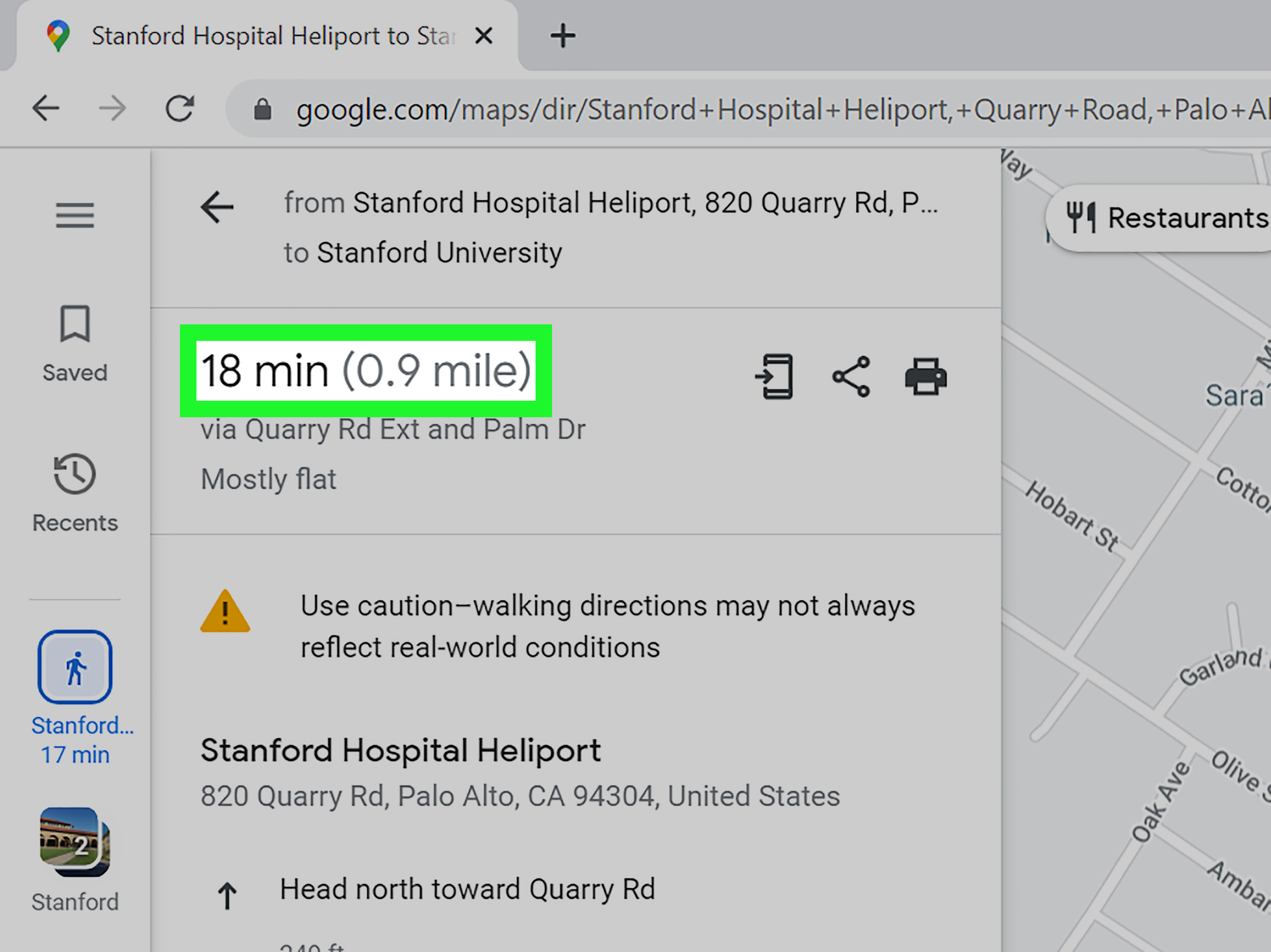
The walking distance usually appears near the route summary, often beside or below the estimated time. For example, Google Maps may show something like “18 min” and “0.8 mi.” That means Google estimates the walk will take about 18 minutes and cover about 0.8 miles.
Step 6: Compare alternate walking routes
If alternate routes are available, Google Maps may display them as gray lines. Tap a gray route to compare the walking distance and estimated time. This is useful when one route is shorter but less pleasant, while another is slightly longer but easier to follow. Sometimes the “best” route is not the shortest one; it may be the route with better sidewalks, fewer turns, or a more practical crossing.
How to See Walking Distance on Google Maps Desktop
Using Google Maps on a computer gives you a larger view, which is excellent for planning walks before you leave. It is also handy if you like seeing the whole route without pinching and zooming like you are trying to solve a spy puzzle.
Step 1: Open Google Maps in your browser
Go to Google Maps on your desktop browser. Chrome, Edge, Firefox, and Safari all work, although the experience may vary slightly depending on browser settings and account status.
Step 2: Search for your destination
Use the search bar in the upper-left corner to find the place you want to walk to. Click the correct result when it appears.
Step 3: Click “Directions”
Click the Directions button. Google Maps will ask for a starting point. You can type an address, a landmark, a business name, or choose your current location if your browser has permission to access it.
Step 4: Select walking mode
Click the walking icon at the top of the route panel. Google Maps will update the route to show walking directions instead of driving or transit directions.
Step 5: Check the route distance
The left-side panel will show the estimated walking time and distance. You may also see multiple route options. Click a different route line to compare distances and travel times.
How to Measure a Custom Walking Distance on Google Maps Mobile
Sometimes you do not want directions to a business or address. You want to measure your own walking loop, trail, campus path, or “how far is it if I wander through the park and pretend I am a peaceful person?” route. That is where the Measure distance tool helps.
On Android or iPhone
- Open the Google Maps app.
- Touch and hold a spot on the map that is not already labeled with a place name or icon.
- Wait for a red pin to appear.
- Tap the place card at the bottom if needed.
- Select Measure distance.
- Move the map so the black circle is over your next point.
- Tap Add point.
- Repeat the process to create a custom walking path.
As you add points, Google Maps shows the total distance at the bottom of the screen. This can be displayed in miles and kilometers, depending on your settings and region. You can add several points to follow curves, turns, paths, and loops more accurately.
When to use Measure Distance instead of Directions
Use Directions when you want Google Maps to choose a walkable route. Use Measure distance when you want to create your own path. For example, if you are planning a 2-mile morning walk around your neighborhood, measuring points manually may work better than asking for directions to one destination.
How to Measure Walking Distance on Google Maps Desktop
The desktop version of Google Maps has one of the easiest distance-measuring tools. It is great for planning loops, estimating trail length, or checking whether that “five-minute walk” listed in a rental ad was written by a professional optimist.
Steps for desktop measurement
- Open Google Maps on your computer.
- Right-click your starting point on the map.
- Select Measure distance.
- Click the next point on the map.
- Continue clicking additional points to follow your route.
- Look at the distance box at the bottom of the screen.
You can drag points to adjust the path or click a point to remove it. This makes desktop Google Maps especially useful for planning a walk with several turns. If you want to measure around a park, click along the path instead of drawing one giant diagonal line through trees, fountains, and possibly someone’s picnic.
Walking Directions vs. Measure Distance: Which Is More Accurate?
For real-world walking from one place to another, walking directions are usually more practical because they follow available routes. Google Maps considers paths, roads, intersections, and mapped walkways when creating directions. It may also show alternate routes if there are several ways to walk to the same destination.
The Measure distance tool is accurate for the points you place, but it does not automatically know your exact intended walking path. If you place only two points, you may get a straight-line distance, which is useful for “as the crow flies” measurement but not always useful for actual walking. Unless you are a crow, in which case congratulations on reading HTML.
For the best manual estimate, add enough points to follow the real path closely. A curved trail needs more points than a straight city block. A neighborhood loop may need points at every corner. A hiking path may require careful zooming so you do not accidentally measure through a ravine like a cartoon character.
How to Change Walking Distance Units: Miles or Kilometers
Google Maps usually chooses miles or kilometers based on your region and settings. In the mobile app, you can often adjust distance units by opening your profile picture or initial, going to Settings, and looking for navigation or distance unit options. You may see choices such as automatic, miles, or kilometers.
On desktop, Google Maps may display units based on your region, language settings, or route options. In many cases, measured distance can show both miles and kilometers, especially when using the manual Measure distance tool. If the wrong unit appears, check your Google account language, browser region, or Maps settings where available.
How to View Walking Directions Step by Step
Distance is helpful, but sometimes you need the actual walking instructions too. On mobile, after choosing walking directions, tap the route card or swipe up from the bottom to see detailed steps. You may see turn-by-turn directions such as “Head north,” “Turn right,” or “Take the pedestrian path.”
On desktop, click the route details in the left panel. Google Maps will expand the walking steps. This is helpful when you want to preview the route before leaving or send directions to your phone.
Can Google Maps Show Live Walking Navigation?
Yes. On mobile, Google Maps can provide walking navigation. After choosing a walking route, tap Start to begin navigation from your current location. In supported areas and on compatible devices, you may also see camera-based walking guidance through Google Maps’ visual navigation features. This can help when you exit a subway station, leave a large building, or stand on a corner wondering which way is “slightly northeast.”
Still, keep your eyes on the real world. Google Maps is useful, but sidewalks, construction zones, temporary closures, and local signs matter. Do not follow your phone into a fountain. The phone will not apologize properly.
Why Google Maps Walking Distance May Look Wrong
Sometimes the walking distance in Google Maps may seem too long, too short, or just plain suspicious. Here are the usual reasons.
1. The route avoids unsafe or unavailable paths
Google Maps may avoid private roads, restricted areas, highways, or unmapped shortcuts. A local may know a cut-through path, but if it is not mapped or considered walkable, Google Maps may choose a longer official route.
2. Your starting point is slightly off
If your GPS location is inaccurate, your walking distance may start from the wrong side of a building, street, mall, or park. Zoom in and check your starting point before trusting the distance.
3. You are viewing driving directions by accident
This is common. If the distance looks strange, check the transportation mode. Make sure the walking icon is selected. Driving routes and walking routes can be very different, especially in downtown areas, campuses, parks, and neighborhoods with pedestrian shortcuts.
4. The walking path is not mapped
Some sidewalks, trails, alleys, and shortcuts may not be available in Google Maps. In that case, the app may route around them. You can report missing roads or incorrect directions through Google Maps feedback tools.
5. Temporary conditions are not reflected
Construction, events, weather damage, closed gates, and local restrictions can affect real walking routes. Google Maps is powerful, but it is not a crystal ball wearing sneakers.
Practical Examples
Example 1: Checking the walk from a hotel to a restaurant
Search for the restaurant, tap Directions, choose the walking icon, and check the distance. If it says 0.4 miles and 8 minutes, that is probably a comfortable walk for many people. If it says 2.1 miles and 44 minutes, maybe reconsider your shoes, your schedule, or your confidence.
Example 2: Planning a 3-mile neighborhood walk
Use the Measure distance tool. Drop your first point at home, then add points at each turn until the loop reaches about 3 miles. On desktop, this is especially easy because you can right-click, measure, and adjust points with your mouse.
Example 3: Comparing two walking routes to a train station
Use walking directions and check alternate gray routes. One route may be shorter, while another may use larger streets or fewer turns. If you are walking at night or in an unfamiliar place, the slightly longer route may be the smarter choice.
Troubleshooting: What If You Cannot See Walking Distance?
Update the Google Maps app
If buttons are missing or the layout looks different from current instructions, update Google Maps from the App Store or Google Play. App features and designs change over time.
Check your internet connection
Walking routes require map data. If your connection is weak, Google Maps may fail to load the route or show incomplete information.
Zoom in closer
For manual measurement, zooming in helps you place points more accurately. This is especially important for trails, parks, campuses, and dense city blocks.
Tap the correct place card
On mobile, the Measure distance option appears after dropping a pin. If you tap a business or landmark instead, you may see business details instead of the measuring tool. Touch and hold an empty map area to drop a plain pin.
Try desktop for complex routes
If you are planning a detailed walking loop, desktop is often easier than mobile. The bigger screen helps you see intersections, path curves, and measurement points clearly.
Tips for Better Walking Distance Estimates
First, use walking directions for real trips and manual measurement for custom walks. Second, compare alternate routes instead of accepting the first one automatically. Third, zoom in before measuring. Fourth, remember that estimated walking time is not a personal fitness judgment. Google Maps does not know whether you are power-walking, sightseeing, pushing a stroller, walking a dog, carrying groceries, or stopping every two blocks to take photos of suspiciously cute buildings.
For longer walks, consider terrain, weather, traffic crossings, lighting, and safety. A flat 1.5-mile walk through a shaded neighborhood feels different from a 1.5-mile walk uphill in August while the sun behaves like a personal enemy. Distance is only one part of the walking experience.
Extra Experience: Real-World Lessons from Using Google Maps for Walking Distance
After using Google Maps for walking routes in cities, parks, airports, campuses, and neighborhoods, one lesson becomes obvious: the number on the screen is helpful, but context is king. A half-mile walk can feel breezy when the sidewalks are wide, the weather is pleasant, and the route has clear crossings. The same half-mile can feel like a quest from a fantasy novel when it involves confusing intersections, poor lighting, construction barriers, or a hill that seems personally offended by your existence.
The most useful habit is checking both the map line and the step-by-step directions before starting. The distance alone tells you how far. The route tells you how annoying it might be. For example, two walking routes may both be 0.7 miles, but one may require crossing several busy roads, while another follows a quieter path through a park. On paper, they are equal. On your feet, they are not even cousins.
Another practical trick is to zoom in around the starting point and destination. Google Maps may route you to the front entrance of a building, but large places such as malls, hospitals, stadiums, universities, apartment complexes, and train stations can have multiple entrances. If the destination is huge, the final 300 feet can become the most confusing part of the walk. Checking the exact entrance can save time, irritation, and the classic “I am here, but not emotionally here” moment.
Manual distance measurement is especially useful for fitness walks. Instead of choosing a destination, you can build a loop that matches your goal. Want a 1-mile lunch walk? Drop points around nearby blocks. Want a 5K-style route? Keep adding points until the total distance reaches about 3.1 miles. Desktop is better for this because clicking and adjusting points with a mouse feels cleaner than dragging a tiny map on a phone while your thumb blocks half the neighborhood.
For travel, walking distance can help you make smarter booking decisions. A hotel that is “near downtown” may still be a 28-minute walk from the attractions you actually care about. A rental listing that says “steps from transit” may be technically accurate if the person writing it has the stride length of a giraffe. Checking walking distance in Google Maps gives you a reality check before you book.
Finally, remember that Google Maps estimates are not promises carved into stone tablets. Walk speed varies. Crosswalk timing matters. Crowds matter. Weather matters. Your mood matters. If you are walking somewhere important, add a buffer. Google Maps can tell you the route, but it cannot predict that you will stop for iced coffee, pet a friendly dog, or spend four minutes deciding whether the shortcut looks charming or mildly haunted.
Conclusion
Seeing walking distance on Google Maps is simple once you know which tool to use. For a real route, search for your destination, tap or click Directions, choose the walking icon, and read the distance and estimated time. For a custom route, use Measure distance on mobile or desktop and add points along the path you want to walk.
Mobile is best when you are already out and need quick walking directions. Desktop is best when you want to plan carefully, compare routes, or measure a custom loop. Either way, Google Maps can help you decide whether a walk is pleasantly doable, mildly ambitious, or a “maybe I should call a ride” situation.
Note: Google Maps features and labels may vary by app version, device, browser, region, and account settings. Always pay attention to local signs, sidewalks, closures, and real-world safety conditions while walking.